

Lun - Ven 8:30/12:30
14:00/18:00
Sab 8:30/12:30
14:00/18:00
Sab 8:30/12:30
Tel: +39.347.123.0579
info@northair.it
info@northair.it

p/n. 010-01998-05 / 010-02044-20 / 013-00235-00
Il pacchetto include:
1- GTN 635Xi black receiver w/rack, backplate, conn kit, config module and product
information kit*
2- SD Datacard (NavData, Terrain, Obstacle, FliteCharts, SafeTaxi) International
3- GA 35 GPS/WAAS antenna
Sistema GPS / MFD integrato
Display LCD da 4.9" touchscreen
Pianificazione di volo grafica
Traffico, meteo e altro
LPV glidepath avvicina.
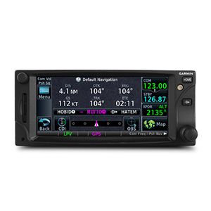
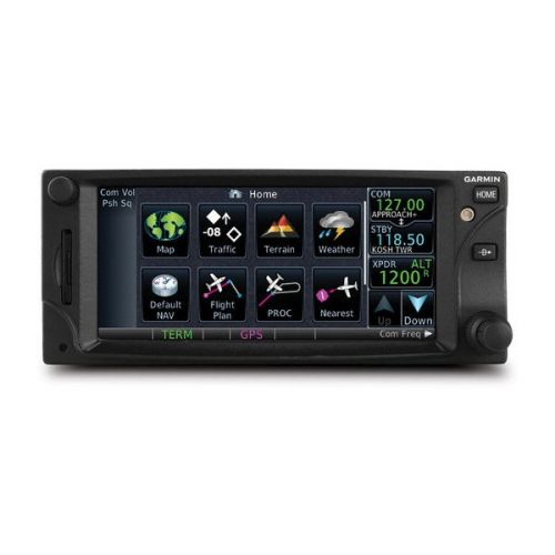
Il GTN 635Xi è un navigatore GPS in formato rack standard 2.64" che permette di avere la mappatura ad alta risoluzione del terreno, la pianificazione di volo grafica, visualizzazione del traffico e del meteo e molto altro.
Tocca e vai!!!
Con la sua interfaccia touchscreen rivoluzionaria il GTN 635Xi offre le funzioni primarie in pochi click! Facendo una panoramica della schermata della mappa scorrendo il dito sul display TFT da 4,9" ad alta risoluzione è possibile inserire i dati waypoint con l'entrata alfanumerica sullo schermo. Le prese in lunetta e un ripiano lungo il bordo inferiore dello schermo agiscono come punti di presa sia in condizioni di volo tranquillo che di volo turbolento. Manopole concentriche tradizionali sono disponibili anche per l'input dei dati. Se avete un GNS 430W/530W, piani di volo attivi crossfill passano automaticamente dal GTN al GNS o semplicemente attivando waypoint utente, si può fare manualmente trasferirli tra i dispositivi .
Navigare con facilità
Modificare l'intero percorso utilizzando la schermata della mappa e inserire nuovi waypoint o modificare quelli esistenti . Una comoda funzione "rubber band" letteralmente " elastico " consente di afferrare ogni tappa del vostro piano di volo o direct-to rotta e spostarla per ospitare una deviazione o ATC ??modifica il piano di volo . Inserisci le tue destinazioni più visitate di recente o aeroporti più vicini come waypoints e "Direct To " .
Eseguire avvicinamenti di precisione
I 15 canali posizione del ricevitore GPS Generano 5 aggiornamenti al secondo. Questa tecnologia SBAS / WAAS certificata consente di volare LPV strumento glidepath GPS a guida in avvicinamento fino a partire da 200 ft . In aggiunta , le uscite precise corso deviazione e roll sterzo possono essere accoppiate per selezionare autopiloti così che le procedure di volo IFR possano essere volate automaticamente. Questo include tutti gli ARINC 424 tipi di gamba, tranne le gambe RF.
Vedere più che mai
GTN 635Xi porta una maggiore consapevolezza della situazione alla cabina di guida. Con la mappatura del terreno ad alta risoluzione - incluse le funzioni topografia, città , aeroporti , aree terminali e suas - e opzionale di avviso di Classe B TAWS , troverete il modo per aggirare lo spazio aereo in tutta sicurezza e con facilità . ™ di Smart Airspace evidenzia automaticamente lo spazio aereo vicino alla vostra altitudine attuale e de- enfatizza lo spazio aereo dalla quota attuale . Il sistema permette anche di caricare e seguire Victor e Jet Airways . Sul terreno , built-in SafeTaxi ® diagrammi aeroportuali offrono piste georeferenziati , vie di rullaggio , OSA e hangar disponibili negli Stati Uniti , in Europa o in Canada .
Aggiungi Traffico , Meteo e molto altro
Il GDL dual-link ® 88 Consente al GTN 635Xi di visualizzare fino a 60 bersagli traffico ADS- B. TargetTrend ™ tecnologia a moto relativo offre un modo più veloce per giudicare la direzione e la velocità di chiusura intrusione obiettivi in relazione alla posizione dei loro aerei. SURF è l'unica tecnologia che supporta la visualizzazione di bersagli di superficie ADS - B - attrezzati in SafeTaxi diagrammi aeroportuali , tra cui il rullaggio aeromobili e veicoli terrestri. Anche GDL 88 può ricevere gratis l'abbonamento FAA - FIS - B trasmissioni climatiche che include informazioni radar NEXRAD grafica , così come NOTAM , METAR e TAF. GTN dà il GDL 88 WAAS fonte posizione richiesta per ADS - B; la versione WAAS del GDL 88 non è richiesta. Considerare l'aggiunta di un sistema di traffico per complimentarmi GDL 88 per la migliore copertura possibile del traffico da qui al 2020.
Agganciare il sistema con un ricevitore datalink 69 serie GDL ® permette di ricevere MX XM Satellite Meteo e SiriusXM Satellite Radio ( abbonamenti richiesti). Un GSR opzionale 56 fornisce i dati World Weather tutto praticamente ovunque sul globo , così come la possibilità di effettuare e ricevere chiamate ed inviare e ricevere testi dei messaggi , mentre si è in aria .
Il GTN 625Xi può controllare l'installazione del GTX ™ 33 transponder. Inoltre si potrebbe risparmiare spazio prezioso nel quadro.
Vola con miglioramenti
Il GTN 635Xi è disponibile con una serie di accessori opzionali per contribuire a soddisfare le esigenze uniche di missioni in elicottero . E 'stato progettato per soddisfare le vibrazioni degli elicotteri e i test di temperatura standard rigorosi necessari per la qualificazione ambientale. Dispone inoltre di un database di ostacolo specifico elicottero che aggiunge quasi 30.000 ostacoli a bassa quota , così come un database di navigazione con eliporti e il database del terreno ad alta risoluzione. Per maggiore sicurezza, HTAWS, ( funzione opzionale), fornisce ombreggiatura e 5 colori per mostrare il terreno in prossimità del vostro elicottero e fornisce richiami vocali quando scende sotto i 500.
Rimanere aggiornati
Il GTN 635Xi dispone di un lettore di schede SD ™ con caricamento frontale, in modo da poter facilmente aggiornare i database. Fasci di database PilotPak ™ sono ora disponibili su una base unico aeromobile, per risparmiare denaro e semplificare il processo di aggiornamento.
GTN 635Xi è ora disponibile per l'acquisto presso il vostro rivenditore Garmin autorizzato. Guardalo in azione a un seminario imminente o in versione demo presso un rivenditore, o con il nostro allenatore che puoi scaricare gratis da PC o iPad ®.
****************************************************************************************************
The 2.64 " GTN 635Xi puts high resolution terrain mapping, graphical flight planning, traffic display and multiple weather options right at your fingertips .
Touch and Go
With its revolutionary touchscreen interface , GTN 635Xi puts primary functions just a few taps away . Pan across the map screen by swiping your finger across the 4.9 "high -resolution TFT display , and enter waypoint data with the onscreen alphanumeric entry . Raised grips in the bezel and a shelf across the lower edge of the screen acts as gripping points in both smooth and turbulent flight conditions. Traditional concentric knobs are also available for data input. If you have a GNS 430W/530W , active flight plans automatically crossfill from the GTN to the GNS , or just manually crossfill user waypoints between devices.
Navigate with Ease
Edit your entire route using the map screen and enter new waypoints or modify existing ones , and load Victor and jet airways . A handy "rubber band " feature lets you grab any leg of your flight plan or direct-to route and move it to accommodate a deviation or ATC amendment to your flight plan . Enter your most recently visited or nearest airports as waypoints and "Direct To" destinations .
The robust 15 -channel GPS receiver position Generates 5 updates per second . This SBAS / WAAS -certified technology Allows you to fly GPS -guided LPV glidepath instrument approaches down to as low as 200 ft . In Addition , precise course deviation and roll steering outputs can be coupled to select Autopilots So THAT IFR flight procedures may be flown automatically. This includes all ARINC 424 leg types , except RF legs . ( For example , When coupled with a G500/G600 Flight Display , the aircraft can fly fully coupled missed approaches , including heading legs . )
Make Communication a Breeze
A fully certified , 2,280 -channel VHF communications transceiver Provides a standard 10 W ( or optional 16 W ) of power output. The system is pilot- selectable to both 25 kHz and 8:33 kHz channel spacing . Set your standby Com frequency simply by touching the onscreen number pad . Another touch of the screen switches your active and standby frequencies . Recent and favorite user frequencies are Also a breeze to access. For added safety , holding down the volume knob will automatically dial in the emergency frequency .
See More Than Ever Before
GTN 6d5 brings enhanced situational awareness to your cockpit . With high-resolution terrain mapping - including topography features , cities , airports , terminal areas and suas - and optional Class B TAWS alerting , you'll find your way around the airspace safely and with ease . ™ Smart Airspace automatically highlights airspace close to your current altitude and de -emphasizes airspace away from the current altitude . The system even Allows you to load and follow Victor and jet airways . On the ground , built-in SafeTaxi ® airport diagrams give you geo -referenced runways , taxiways , FBOs and hangars available in either the U.S. , Europe or Canada.
Add Traffic , Weather & More
The dual-link GDL ® 88 Allows the GTN 635Xi to display up to 60 ADS -B traffic targets . TargetTrend ™ relative motion technology offers pilots a faster way to judge the direction and rate of closure intruding targets in relation to Their aircraft 's position. SURF and unique technology supports the display of ADS -B -equipped surface targets on SafeTaxi airport diagrams, including taxiing aircraft and ground vehicles. Also GDL 88 can receive the FAA 's subscription - free FIS -B weather broadcasts That includes graphical NEXRAD radar information , as well as NOTAMs , METARs and TAFs . GTN Gives GDL 88 with the required WAAS position source for ADS -B , I know WAAS version of the GDL 88 is not required . Consider adding a Traffic System to compliment the GDL 88 To provide the best possible traffic coverage from now until 2020 .
Couple the system with a GDL ® 69 series datalink receiver to receive MX XM Satellite Weather and SiriusXM Satellite Radio ( subscriptions required) . An optional GSR 56 Provides World Wide Weather data virtually anywhere on the globe , as well as the ability to make and receive phone calls and send and receive texts messages while in the air .
And Because The GTN 635Xi can control the GTX ™ 33 remote transponder , a GTN 635Xi Also installation could save you valuable panel space .
Fly with Helicopter -Specific Enhancements
The GTN 635Xi is available with a number of optional enhancements to help meet the unique demands of helicopter missions . It's been designed to meet the stringent helicopter vibration and temperature testing standards needed for environmental qualification . It also features a helicopter -specific database obstacle That adds nearly 30,000 low-altitude obstacles , as well as a navigation database with heliports and high -resolution terrain database. For added safety , HTAWS Provides optional 5 -color shading to show nearby terrain in proximity to your helicopter and Provides voice callouts When descending below 500
Stay Up to Date
The GTN 635Xi features a front- loading SD ™ card reader, so you can easily update your databases. PilotPak ™ database bundles are now available on a single aircraft basis , saving you money and Simplifying the update process. Visit flyGarmin.com to learn more .
GTN 635Xi is now available for purchase from your Garmin Authorized Dealer . See it in action at an upcoming seminar or in person at a dealer demo location, or with our trainer download free PC or iPad ® app .
